Saturday, January 29, 2011

7 - Ilfracombe to Woolacombe

Stage Distance: 8 miles (Total Distance: 49 miles)
Decent, although cold, weather and the first free weekend since Christmas.  Retraced our steps back to Torrs Walk Avenue in Ilfacombe and re-joined the coast path.  Following a zig-zag climb up Seven Hills the walk is across open fields past Breakneck and Brandy Cove Points, with their smuggling connections, to Flat Point where a metalled road descends to Lee Bay.   After a quick lunch by the Lee Bay Hotel we headed up towards Damage Cliffs.  Between this point and Bull Point, the path drops 200ft and rises again twice.  The razor-sharp rocks at Bull Point are very impressive and it's obvious why they are treacherous if you're a boat!

The guide book was encouraging when it came to seeing seals along the coast around Rockham Beach but no such luck for us.  The sun came out as we approached Morte Point which higlighted the jagged rocks as well as forming some nice crepuscular rays over Baggy Point in the middle distance.

Once we had rounded Morte Point, Woolacombe and the wide sweep of Woolacombe Sand became visible.  We're in for a few flat stages from here on. 

Logistics: Parked in Woolacombe and caught the 31 bus back to Ilfracombe.
GPS Track: 7- Ilfracombe to Woolacombe (20110129).kmz 
Images: 7 - Ilfracombe to Woolacombe

Friday, October 22, 2010

6 - Combe Martin to Ilfracombe

Stage Distance: 5.5 miles (Total Distance: 41 miles)


First, a 30 minute bus trip from Ilfracombe to Combe Martin.  Started walking by 12:00.  A steady climb out of Combe Martin.   Had a cup of coffee with our lunch at Sandycove Hotel.  Then past lovely Golden Cove and on to Water Mouth.  This is a very pretty natural harbour.  The tide was out which was ideal as we could walk over the sand to rejoin the path rather than brave the road.   

Up the hill to Widmouth Head with great views back to Water Mouth and on to Samson's Bay and Rillage Point.  Then across the cliffs of Hele Bay, past the Coastguard cottages.  On the way down, we managed to sneak a look through a kind man's scope to view two resident peregrines on the cliffs.  

There followed a steep climb up Beacon Point which gave us great views over to Ilfracombe and the Iron Age hill fortifications of Hillsborough.  From then on it was downhill, over Hillsborough and into Ilfacombe harbour.  We had a walk up to St Nicholas Chapel which was closed and then carried on round Capstone Parade.  We continued along Torr's Walk Avenue until the coast path turned right on toward Woolacombe at which point we left it to return to the car.  A good walk and a fair amount of sun. Fish and chips at the Tarka Inn on the trip home completed the day.

Logistics: Parked at Wilder Road car park in Ilfracombe and caught the 31 bus back to Combe Martin.
GPS Track: 6- Combe Martin to Ilfracombe (20101022).kmz
Images: 6 - Combe Martin to Ilfracombe

Sunday, September 26, 2010

5 - Hunter's Inn to Combe Martin

Stage Distance: 7 miles (Total Distance: 35.5 miles)

 Another glorious morning! Through the gardens of The Hunter's Inn and back to the stone bridge where we picked up the coast path again.  A steep zig-zag up through Heddon's Mouth Wood and up side of the cleave out onto heather-covered moorland.  A quick stop to recover at Peter Rock with fine views down to Highveer Point at the mouth of the cleave.

The view stretched westward along the coast for miles from High Cliff.  We stopped for lunch in the field above the pleasantly-named North Cleave Gut where it was warm and sheltered from the strong wind.

On past Neck Wood, clinging to the cliffside (the wood, not us) and then onto the open moorland of Trentishoe Down where we were entertained by a paraglider.  We soon got our first view of Great Hangman, the highest point on the whole South West Coast path.  Unfortunately, the climb up Great Hangman is prefaced by a very steep descent down to Sherrycombe.  Saw a lovely adder on the way down but before the camera could be brought to bear, our stomping had scared it off.

From Sherrycombe, we started the steep climb up Girt Down (renamed Girt Up by us of course), finally reaching the cairn on Great Hangman.  The views in all directions were spectacular (see the banner photo on the blog among others).  From then on, it was down, past Little Hangman, Lester Cliff and Wild Pear Beach, finally reaching the Kiln Car Park in Combe Martin and the car.  Three great days of walking and very lucky with the weather!

Logistics: Parked at Kiln car park, Combe Martin and booked a taxi back to Hunter's Inn (cost £15).
GPS Track: 5 - Hunter's Inn to Combe Martin (20100926).kmz
Images: 5 - Hunter's Inn to Combe Martin


Saturday, September 25, 2010

4 - Lynmouth to Hunter's Inn

Stage Distance: 7 miles (Total Distance: 28.5 miles)

The second day of our weekend away in Lynton and the weather was clear and sunny.  Starting from Lynmouth, we took the cliff railway up to Lynton and then followed the path out along the cliffs to the Valley of Rocks.  We then continued through the Lee Abbey estate and had lunch on Crock Point with lovely views back to Lee Abbey and the tower on Duty Point.  

There followed a section of woodland walking through Croscombe Wood and Woodybay Wood and then along the cliff path to the impressive Hollow Brook waterfall.  On reaching Heddon's Mouth we followed the coast path inland until we parted company with it at the small stone bridge and continued inland to The Hunter's Inn for nice cuppa and the reunion with the car.

Logistics: Parked at Hunter's Inn and booked a taxi back to Lynmouth (cost £12).
GPS Track: 4 - Lynmouth to Hunter's Inn (20100925).kmz
Images: 4 - Lynmouth to Hunter's Inn


Friday, September 24, 2010

3 - County Gate to Lynmouth

Stage Distance: 6 miles (Total Distance: 21.5 miles)

A bit overcast and very windy at County Gate car park.  First, the long walk down to rejoin the coast path at Sister's Fountain, a small holy well or spring beneath a 19th century stone structure and cross - very atmospheric.

The walk continued through woodland until emerging onto Glenthorne Cliffs and then following the lighthouse access road to the optional walk out to Devon’s most northerly point: the lighthouse at Foreland Point.  On returning from the lighthouse the path climbed up the side of the scree-covered valley and finally onto the cliff tops with our first distant view of Lynmouth.  A quick look around Countisbury Church and then along the cliffs to join the A39 briefly before taking the zig-zagging path down through the woods to Lynmouth beach.

We stayed for 2 nights in Lynton at the  St. Vincent House Hotel.  A lovely house and very good food.  A really civilised end to the day.

Logistics: Parked at Lynmouth and caught the 300 bus back to County Gate.
GPS Track: 3 - County Gate to Lynmouth (20100924).kmz
Images: 3 - County Gate to Lynmouth


Monday, September 13, 2010

2 - Porlock Weir to County Gate

Stage Distance: 6 miles (Total Distance: 15.5 miles)

A dull day with a cold wind blowing.  We had seconds to get from the car to the bus stop and made a very undignified start to the walk by running barefoot clutching our boots, coats and bags, much to the amusement of the passengers.  

This majority of this stage was through woodland.  We ate lunch in Culbone churchyard.  Culbone Church is apparently the smallest complete parish church in England at only 35ft long.  The scenery between Porlock Weir and Lynmouth was thought to be the inspiration for Samuel Taylor Coleridge’s Kubla Khan and The Ancient Mariner, both written while staying on Exmoor.  The walk passed through numerous coombes each with their trickling stream; Silcombe Combe, Holmer's Combe, Twitchen Combe.  We came across a recent major landslide that had since been made passable again.  The walk finished with a long climb up to a very windy County Gate carpark just as it was getting dusk. Lovely views over the Doone Valley.

Logistics: Parked at County Gate and caught the 300 bus back to Porlock.
GPS Track: 2 - Porlock Weir to County Gate (20100913).kmz
Images: 2 - Porlock Weir to County Gate


Saturday, July 31, 2010

1 - Minehead to Porlock Weir

Stage Distance: 9.5 miles (Total Distance: 9.5 miles)
GPS Track: 1 - Minehead to Porlock Weir (20100731).kmz

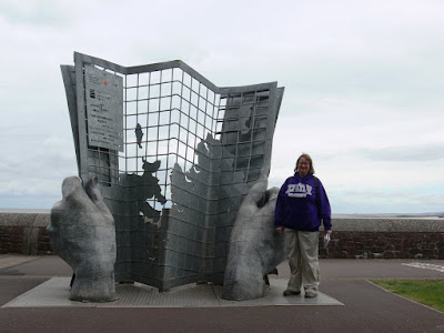
The journey begins!  The first stage!  A warm July day, just right for walking.  This stage started with a photo opportunity at the official start point of the walk and then a long climb out of Minehead, through woodland.  Eventually, the walk emerged on open moorland.

The knee-aching descent through Hurlestone Combe was followed by a pleasant flat walk through Bossington and across the back of Porlock Beach and the eerie marshland populated with dead trees, killed by the encroaching salt water.

A final walk over the large pebbles on Porlock beach led up steps to the road.  Finally back to the car park and a nice pub meal.