It stretches From Minehead on the edge of the Exmoor National Park all the way to Poole Harbour.
Saturday, October 15, 2016
Introduction
The South West Coast Path is a 630-mile footpath around the coastline of the southwest peninsula.
It stretches From Minehead on the edge of the Exmoor National Park all the way to Poole Harbour.
It stretches From Minehead on the edge of the Exmoor National Park all the way to Poole Harbour.

Wednesday, December 28, 2011
18 - Crackington Haven to Boscastle
Stage Distance: 7 miles (Total Distance: 141 miles)

The path climbs out of Crackington Haven, past Bray's Point to Cambeak. Beyond The Strand and The Strangles comes the climb to the top of the 700ft High Cliff. From here, the rock arch called Nether Door can be seen below Cambeak. Time for installment one of the mince pies and nuts.
After another steep descent and ascent, we reach Buckator, with great views back along the coast. Another descent from Buckator into a hanging valley above Gull Rock, mince pies and some nuts, and then the obligatory climb again. Gull Rock looks black and menacing in the seething white water below. We pass a small huddle of ponies with their backs to the wind and soon see the Beeny Sisters below, a number of small semi-submerged rocks in amongst the white water. On past Seals Hole to Pentargon and on to the rather impressive waterfall fed from Beeny, throwing spray backwards all over us. The path then passes along Pentargon Cliff, where it runs along a steep slope down to sheer cliffs below. Not a good place to roll down and a bit unnerving in the high wind. From here, the coast to Tintagel can be seen through the salt spray with ominous clouds overhead.
Finally Penally Hill is reached, with Boscastle harbour spread out below. The lights are just coming on in Boscastle and checking the pedometer, the walk has been more like 9 miles that the expected 7. A bit longer and we would have been walking in the dark. The path descends gradually to the harbour side. The tide is coming in fast and flowing in through the harbour wall upstream. A little walk along the leat and we reach the car park.We're feeling a bit dizzy from the constant buffeting of the wind. Surprisingly, the only remnants of our food supply are the satsumas.
Logistics: Park in Boscastle and drive second car back to Crackington Haven.
GPS Track: 18 - Crackiington Haven to Boscastle (20111228).kmz
Images: 18 - Crackington Haven to Boscastle
Saturday, November 5, 2011
17 - Bude to Crackington Haven
Stage Distance: 9 miles (Total Distance: 134 miles)

Leaving Bude and crossing the canal lock, the path climbs to Compass Point with views back to Bude Haven. It then follows the cliff-top and the road over Efford Down, past Higher and Lower Longbeak and on to Widemouth Sand with Black Rock clearly visible on the beach at low tide. The path then detours inland to avoid crumbling cliffs at Wanson Mouth and follows the coast road uphill. On leaving the road near Bradwell Point it continues steeply down to picturesque Millook Haven (a sheltered spot for a sandwich) before climbing steeply again onto Millook Common.
After a short time, Dizzard Wood comes into view, with its ancient stunted oaks clinging to the side of the cliff and its nationally important lichens before the path drops and rises just south of Chipman Point before passing above Cleave Strand and out to Castle Point.
After passing through Aller Shoot the path climbs onto Pencannow and out to Pencannow Point where Crackginton Haven can be seen clearly below. The path descends gently and joins the beach opposite the car park.
Logistics: Park in Crackington Haven and 595 bus to Bude.
GPS Track: 17 - Bude to Crackginton Haven (20111105).kmz
Images: 17 - Bude to Cra kington Haven
Saturday, October 22, 2011
16 - Morwenstow to Bude
Stage Distance: 8 miles (Total Distance: 125 miles)

A lovely sunny Saturday and another up-and-down stage. Past the Church and along fields to rejoin the coast path at Hawker's Hut - a small grass-roofed hut with fantastic views used by the vicar of Morewentsow for meditation and occasional opium pipe smoking purposes.
After a steep descent down to Tidna Shute and a climb back to the cliff top, there is an option to walk out to Higher Sharpnose Point with fine views in both directions along the coast. On rejoining the main path at the old coastguard lookout, the path skirts close to the cliff edge above Greenway Beach. On reaching the back of a sign and looking on the other side, a weathered message reads "Danger, Cliff liable to subsidence". Useful.
The path descends and rises through Stanbury Mouth and before long, the GCHQ radar station at Cleave Camp is reached with its huge white satellite-tracking dish aerials before the path rejoins the cliff edge at Lower Sharpnose Point. From here there are lovely views back along the coast to Higher Sharpnose Point and on to Bude and beyond.
On past Wren Beach, Duck Pool and out to Steeple Point with its jagged rock formations and more good views in both directions, the path reaches Coombe Valley, followed by Duck Pool. A little further is Warren Point. From here, the jagged, razor-edged Mussel Rock can be seen laying in wait in the surf. The path descends again to Warren Gutter and rises again to the cliff top. After about 1km of flatter walking appears Sandy Mouth with a National Trust cafe (frustratingly closed out of season).
The path continues past Menachurch Point and Northcott Mouth, finally reaching Crooklets Beach and shortly after, Bude Haven and the car. Hard work but great views!
Logistics: Park in Bude and 500 bus to Crackington Haven.
GPS Track: 16 - Morwenstow to Bude (20111022).kmz
Images: 16 - Morwenstow to Bude
Monday, August 29, 2011
15 – Hartland Quay to Morwenstow
Stage Distance: 8 miles (Total Distance: 117 miles)

Low tide at Screda Point means that the rock formations on the beach are clearly visible unlike the day back in May when the tide was fully in.
Rock climbers are busy on Screda Point as we set off at 11:15. The path follows the cliff to the landward side of St. Catherine's Tor. From here, there are clear views to Swansford Hill and beyond. The path soon reaches Speake's Mill Mouth with more beach rock formations and a very impressive waterfall. The views of Lundy are the clearest we've seen since we started on the Coast Path. The route skirts the bottom of Swansford Hill and through the valley before climbing back onto the cliffs. A brief rest above Hole Rock and then it's on to Mansley Cliff backed by fields of newly-bailed hay. There follows a short distance on lanes at Sandhole Cross before heading back to the cliffs and Nabor Point. From here, Hartland Quay is visible in the distance. A well-placed picnic table at Nabor Point means it must be lunch time. We're feeling rather pleased with ourselves at this stage as it hasn't felt too tiring so far. Beyond Gull Rock and Knapp Head we catch the first view of the descent (and ascent) at Welcombe Mouth. Not feeling so smug now. The path winds steeply down to Welcombe Mouth, a very pretty spot with a fast-flowing stream running onto the wide beach. A brief rest and then back up the 400 feet to the cliff top. Before long, it's down again to Marsland Mouth, past the poet Ronald Duncan's hut and across the bridge over the Old Mill Leat. On the far side of the bridge a wooden sign informs us that we're now entering Cornwall! After a brief moment to contemplate this achievement it's back to reality and another climb to the cliff tops and, inevitably, down again into Litter Mouth, with it's dramatic Gull Rock and Devil's Hole. A couple of climbers are sitting at the top of the rocks having a rest - rather them than us. The path climbs again from Litter Mouth to Henna Cliff before descending to Yeol Mouth. Another climb and Morwenstow Church breaks into view. There's still one more down and up to contend with,Vicarage Cliff being the final ascent before we turn inland along the lane back to the Rectory Farm Tea Room (now closed for the day, so we made the right decision in having the cake at the start when we parked). 18:00 by the time we reach the car, which means we've averaged a very embarrassing 1 mile per hour. Must have been a long lunch.
Logistics: Parked one car at Rectory Farm in Morwenstow and drove the second car back to Hartland Quay
GPS Track: 15 - Hartland Quay to Morwenstow (20110829).kmz
Images: 15 - Hartland Quay to Morwenstow
Monday, May 2, 2011
14 - Clovelly to Hartland Quay
Stage Distance: 10 miles (Total Distance: 109 miles)

Passing through the fields by Clovelly Court the path passes through trees and past a number of shelters, the most interesting one being the Angel Wings shelter due to the carvings covering it. There then follows an open stage over Gallantry Bower before the descent to Mouthmill Beach. A lime kiln sits by the stream and on the beach there is the impressive double arch of Blackchurch Rock. Then it's back through bluebells woods onto the cliffs again. Another descent to Windbury Waterfall and then up to Windbury Head with fantastic views back to Blackchurch Rock and along the North Devon coast to Hartland Point and beyond.
On Brownsham Cliff there is a memorial to a Wellington Bomber which crashed in 1942 and more great views from Exmanworthy Cliff. After following a number of field boundaries for what seems like miles, the radar station on West Titchbury Cliff comes into view and after passing that, the first glimpse of the the old lookout post on Hartland Point.
There is no access to the lighthouse on Hartland Point but there are good view of it from the cliff top, particularly from a little further beyond the point itself.
Soon after leaving Hartland Point, Smoothlands can be seen in the middle distance. The path descends again to Titchberry Water, carpeted with flowers before climbing once more to the cliff-tops. Smoothlands is a hanging valley - a former stream bed which is still marshy in places. At the far end is Damehole Point where the path climbs up again with fine views over to Hartland Quay and back across Smoothlands.
Following the path over Blegberry Cliff with more great views, Stoke Church soon comes into view and yet another descent is made to Blackpool Mill and the Abbey River. The final ascent brings us to Warren Cliff and past a ruined tower before finally arriving at Hartland Quay and the car park overlooking the dramatic Screda Point.
It's a long undulating 10 miles but well worth the effort. We've walked a total of 109 miles now. A celebratory lamb shank in the hotel is called for!
Logistics: Parked at Hartland Quay and drove the hire car back to Clovelly
GPS Track: 14 - Clovelly to Hartland Quay (20110502).kmz
Images: 14 - Clovelly to Hartland Quay
Sunday, May 1, 2011
13 - Buck's Mills to Clovelly
Stage Distance: 5 miles (Total Distance: 99 miles)

The path leaves Buck's Mills and zig-zags up through Buck's Wood. Then on through Kevill's and Barton Woods. A real bluebell extravaganza. The scent is almost overpowering at times. A brief walk across open fields and then back into Barton Wood before finally joining the Hobby Drive, built by the landowner in the early 19th century. Projects of this type were usually built by Napoleonic prisoners and the unemployed during times of recession (the Big Society is not new then?). The Hobby Drive continues for 2 or more miles well above Clovelly. Some benches wouldn't go amiss but we settle for lunch on an old felled tree trunk.
On reaching Clovelly, it's down the lovely cobbled streets to the harbour. It's a very picturesque setting, all the more uplifting due to the realisation that we've avoided the £5 per head entrance fee by not arriving through the normal channels! It's a stiff climb back up, so we fully deserve the coffee and cake before heading for the car.
Logistics: Parked at Clovelly and drove the hire car back to Buck's Mills.
GPS Track: 13 - Buck's Mills to Clovelly (20110501).kmz
Images: 13 - Buck's Mills to Clovelly
Saturday, April 30, 2011
12 - Westward Ho! to Buck's Mills
Stage Distance: 6 miles (Total Distance: 94 miles)

The weather is overcast but dry. Passing the last of the chalets in Westward Ho! the path leaves the town and passes over Cornborough, Abbotsham and Green Cliffs. An added bonus early on is the view of a Darftford Warbler, showing nicely on the gorse.
After enjoying the great views along the coast from the top of Green Cliff, the path continues over Cockington Cliff and then descends steeply down to the beach at Westacott Cliff before climbing back up again. A pretty thicket provided some welcome shelter from the strong wind for lunch. Dark thunder clouds passing overhead brings some sharp showers before passing over the Bristol Channel. The path continues over Rowden and down into Peppercombe before passing into Sloo Wood. At this time of the year, the bluebells are carpeting the woods. This and the next stage have a lot of woodland walking so we're in for a treat. Bluebells and dappled sunlight - perfect!
On through Worthygate Wood and soon the path descends to Buck's Mills. A short walk up the road leads back to the car park.
Logistics: Parked at Buck's Mills and drove the hire car back to Westward Ho!.
GPS Track: 12 - Westward Ho! to Buck's Mills (20110430).kmz
Images: 12 - Westward Ho! to Buck's Mills
Friday, March 25, 2011
11 - Bideford to Westward Ho!
Stage Distance: 8 miles (Total Distance: 88 miles)

The low tide route is across the sand to Northam Burrows. From here it’s only 900 yards across the river to Braunton Burrows, but it’s taken a walk of 18 miles to get from there to here!
The path follows the road until it turns into the dunes and on to Grey Sand Hill. It then follows the pebble ridge to Westward Ho! skirting round the landward side of Sandymere.
Logistics: Parked at Westward Ho!and took the 21 bus back to Bideford.
GPS Track: 11 - Bideford to Westward Ho! (20110319).kmz
Images: 11 - Bideford to Westward Ho!
Saturday, March 19, 2011
10 - Barnstaple to Bideford
Stage Distance: 10 miles (Total Distance: 80 miles)

The tiffin cake at Barntaple station is quality stuff! Fortified, we head off to join the Tarka Trail again, this time along the old Barnstaple to Bideford line. A fantastic day! The walk follows the trail all the way to the old station at Fremington Quay,where Devon clay used to be shipped out all over the world. By this time it’s lunchtime (food is starting to feature almost more than the walking in these accounts). There are lovely views across the Taw, made more interesting because the tide is low with the channels flowing across the sand. There are a few birds out there, egret, oystercatcher and curlew, but fewer than in the winter months. The path crosses Fremington Pill and then there is an option to turn off the trail and follow the river through East Yelland Marsh and Instow Barton Marsh. Take it! It makes a nice change from the tarmac of the trail. After passing the old power station site the path eventually drops down onto Instow Sands. Through the village you arrive at the signal box and rejoin the old line towards Bideford.
As you travel along towards Bideford, there are good views back to Instow and Appledore facing each other across the Torridge. The path continues into Bideford with a final signal box to add to the collection. Then across the river via the long bridge and back to the car.
Logistics: Parked at Bideford and 21A, 85 or 315 bus back to Barnstaple railway station).
GPS Track: 10 - Barnstaple to Bideford (20110319).kmz
Images: 10 - Barnstaple to Bideford
Sunday, March 13, 2011
9 - Saunton to Barnstaple
Stage Distance: 12.5 miles (Total Distance: 70 miles)
 The next three stages will take us inland up the Taw and Torridge rivers after which we’ll rejoin the coast again at Westward Ho!
Another choice to start with - along the road or the alternative climb up through the trees behind the road onto Saunton Down to rejoin the road further down? The Saunton Down route is highly recommended as it gives wonderful views across Saunton Sands and Braunton Burrows across to the Taw/Torridge in the distance as well as being a very pleasant walk over fields. We won’t be this high again until well past Westward Ho!.
The path over the downs descends near Saunton Court and rejoins the road. Then it’s into Braunton Burrows. They look much more attractive in sunshine than in the dull light the day before.
On through the Burrows until eventually meeting the Taw/Torridge estuary, which seems a sensible place for lunch. An optional boardwalk is laid over the dunes to Broad Sand overlooking Appledore and it’s worth the walk there and back.
After passing a lovely tranquil lake, the walk eventually joins the dyke along the banks of the Taw at the White House. It continues, giving pleasant views over Braunton Marshes and the river until it turns towards Braunton along the Caen River. Close to Braunton, the river widens at Velator Quay, once used to deliver limestone and coal from over the Bristol Channel to the local lime kilns. Just after the quay, the path joins the road at the weir in Braunton. A short walk through the outskirts and then onto the Tarka Trail – the old Barnstaple to Ilfracombe railway. On it goes past Chivenor, the base for the yellow helicopter often seen patrolling the coast and a tea stop at the Tarka Inn at the point where the trail rejoins the Taw. The last mile or two is along the river bank until arriving at the road bridge. After crossing the river it’s a brief walk via the underpass back to the Tesco car park where, to our relief, we have not been clamped! Cheap but risky!
Logistics: Parked at Barnstaple booked a taxi to Woolacombe (no 308 bus on Sundays!).
GPS Track: 9- Saunton to Barnstaple (20110313).kmz
Images: 9 - Saunton to Barnstaple
Saturday, March 12, 2011
8 - Woolacombe to Saunton
Stage Distance: 8.5 miles (Total Distance: 57.5 miles)
On rounding the Point, Croyde Sand soon comes into view. The path following the cliff edge passes an unexpected whale vertebra and reaches Croyde where a very well-placed café exerts it’s attraction.
One cream tea later (shared, mind you) and the promised rain looks imminent. Walking across Croyde Sand threatens to be wet but it comes to nothing. Woolacombe appears less lucky though, looking back.
The path leaves the sand and climbs up past the old coastguard lookout to join the road. At this point there is a choice; continue back along the road to Saunton or take an alternative loop climbing up behind the road and descend to rejoin it opposite the Saunton Sands Hotel. The loop is more enjoyable but obviously longer. On rejoining the road at the hotel, the path continues through the hotel grounds and descends to the car park.
Logistics: Parked at Saunton and caught the 308 bus to Bruunton and the 303 bus to Woolacombe.
GPS Track: 8- Woolacombe to Saunton(20110312).kmz
Images: 8 - Woolacombe to Saunton
Saturday, January 29, 2011
7 - Ilfracombe to Woolacombe
Stage Distance: 8 miles (Total Distance: 49 miles)


The guide book was encouraging when it came to seeing seals along the coast around Rockham Beach but no such luck for us. The sun came out as we approached Morte Point which higlighted the jagged rocks as well as forming some nice crepuscular rays over Baggy Point in the middle distance.
Once we had rounded Morte Point, Woolacombe and the wide sweep of Woolacombe Sand became visible. We're in for a few flat stages from here on.
Logistics: Parked in Woolacombe and caught the 31 bus back to Ilfracombe.
GPS Track: 7- Ilfracombe to Woolacombe (20110129).kmz
Images: 7 - Ilfracombe to Woolacombe
Friday, October 22, 2010
6 - Combe Martin to Ilfracombe
Stage Distance: 5.5 miles (Total Distance: 41 miles)
.JPG)
First, a 30 minute bus trip from Ilfracombe to Combe Martin. Started walking by 12:00. A steady climb out of Combe Martin. Had a cup of coffee with our lunch at Sandycove Hotel. Then past lovely Golden Cove and on to Water Mouth. This is a very pretty natural harbour. The tide was out which was ideal as we could walk over the sand to rejoin the path rather than brave the road.
Up the hill to Widmouth Head with great views back to Water Mouth and on to Samson's Bay and Rillage Point. Then across the cliffs of Hele Bay, past the Coastguard cottages. On the way down, we managed to sneak a look through a kind man's scope to view two resident peregrines on the cliffs.
There followed a steep climb up Beacon Point which gave us great views over to Ilfracombe and the Iron Age hill fortifications of Hillsborough. From then on it was downhill, over Hillsborough and into Ilfacombe harbour. We had a walk up to St Nicholas Chapel which was closed and then carried on round Capstone Parade. We continued along Torr's Walk Avenue until the coast path turned right on toward Woolacombe at which point we left it to return to the car. A good walk and a fair amount of sun. Fish and chips at the Tarka Inn on the trip home completed the day.
Logistics: Parked at Wilder Road car park in Ilfracombe and caught the 31 bus back to Combe Martin.
GPS Track: 6- Combe Martin to Ilfracombe (20101022).kmz
Images: 6 - Combe Martin to Ilfracombe
Sunday, September 26, 2010
5 - Hunter's Inn to Combe Martin
Stage Distance: 7 miles (Total Distance: 35.5 miles)
 Another glorious morning! Through the gardens of The Hunter's Inn and back to the stone bridge where we picked up the coast path again. A steep zig-zag up through Heddon's Mouth Wood and up side of the cleave out onto heather-covered moorland. A quick stop to recover at Peter Rock with fine views down to Highveer Point at the mouth of the cleave.
The view stretched westward along the coast for miles from High Cliff. We stopped for lunch in the field above the pleasantly-named North Cleave Gut where it was warm and sheltered from the strong wind.
On past Neck Wood, clinging to the cliffside (the wood, not us) and then onto the open moorland of Trentishoe Down where we were entertained by a paraglider. We soon got our first view of Great Hangman, the highest point on the whole South West Coast path. Unfortunately, the climb up Great Hangman is prefaced by a very steep descent down to Sherrycombe. Saw a lovely adder on the way down but before the camera could be brought to bear, our stomping had scared it off.
From Sherrycombe, we started the steep climb up Girt Down (renamed Girt Up by us of course), finally reaching the cairn on Great Hangman. The views in all directions were spectacular (see the banner photo on the blog among others). From then on, it was down, past Little Hangman, Lester Cliff and Wild Pear Beach, finally reaching the Kiln Car Park in Combe Martin and the car. Three great days of walking and very lucky with the weather!
Logistics: Parked at Kiln car park, Combe Martin and booked a taxi back to Hunter's Inn (cost £15).
GPS Track: 5 - Hunter's Inn to Combe Martin (20100926).kmz
Images: 5 - Hunter's Inn to Combe Martin
On past Neck Wood, clinging to the cliffside (the wood, not us) and then onto the open moorland of Trentishoe Down where we were entertained by a paraglider. We soon got our first view of Great Hangman, the highest point on the whole South West Coast path. Unfortunately, the climb up Great Hangman is prefaced by a very steep descent down to Sherrycombe. Saw a lovely adder on the way down but before the camera could be brought to bear, our stomping had scared it off.
From Sherrycombe, we started the steep climb up Girt Down (renamed Girt Up by us of course), finally reaching the cairn on Great Hangman. The views in all directions were spectacular (see the banner photo on the blog among others). From then on, it was down, past Little Hangman, Lester Cliff and Wild Pear Beach, finally reaching the Kiln Car Park in Combe Martin and the car. Three great days of walking and very lucky with the weather!
Logistics: Parked at Kiln car park, Combe Martin and booked a taxi back to Hunter's Inn (cost £15).
GPS Track: 5 - Hunter's Inn to Combe Martin (20100926).kmz
Images: 5 - Hunter's Inn to Combe Martin
Saturday, September 25, 2010
4 - Lynmouth to Hunter's Inn
Stage Distance: 7 miles (Total Distance: 28.5 miles)
 The second day of our weekend away in Lynton and the weather was clear and sunny. Starting from Lynmouth, we took the cliff railway up to Lynton and then followed the path out along the cliffs to the Valley of Rocks. We then continued through the Lee Abbey estate and had lunch on Crock Point with lovely views back to Lee Abbey and the tower on Duty Point.
There followed a section of woodland walking through Croscombe Wood and Woodybay Wood and then along the cliff path to the impressive Hollow Brook waterfall. On reaching Heddon's Mouth we followed the coast path inland until we parted company with it at the small stone bridge and continued inland to The Hunter's Inn for nice cuppa and the reunion with the car.

There followed a section of woodland walking through Croscombe Wood and Woodybay Wood and then along the cliff path to the impressive Hollow Brook waterfall. On reaching Heddon's Mouth we followed the coast path inland until we parted company with it at the small stone bridge and continued inland to The Hunter's Inn for nice cuppa and the reunion with the car.
Logistics: Parked at Hunter's Inn and booked a taxi back to Lynmouth (cost £12).
GPS Track: 4 - Lynmouth to Hunter's Inn (20100925).kmz
Images: 4 - Lynmouth to Hunter's Inn
Friday, September 24, 2010
3 - County Gate to Lynmouth
Stage Distance: 6 miles (Total Distance: 21.5 miles)
 A bit overcast and very windy at County Gate car park. First, the long walk down to rejoin the coast path at Sister's Fountain, a small holy well or spring beneath a 19th century stone structure and cross - very atmospheric.
The walk continued through woodland until emerging onto Glenthorne Cliffs and then following the lighthouse access road to the optional walk out to Devon’s most northerly point: the lighthouse at Foreland Point. On returning from the lighthouse the path climbed up the side of the scree-covered valley and finally onto the cliff tops with our first distant view of Lynmouth. A quick look around Countisbury Church and then along the cliffs to join the A39 briefly before taking the zig-zagging path down through the woods to Lynmouth beach.
We stayed for 2 nights in Lynton at the St. Vincent House Hotel. A lovely house and very good food. A really civilised end to the day.
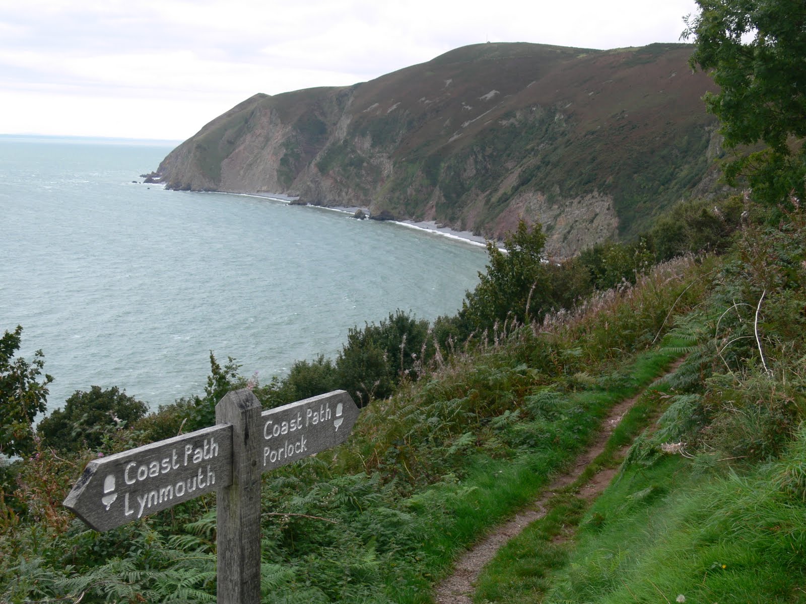 A bit overcast and very windy at County Gate car park. First, the long walk down to rejoin the coast path at Sister's Fountain, a small holy well or spring beneath a 19th century stone structure and cross - very atmospheric.
The walk continued through woodland until emerging onto Glenthorne Cliffs and then following the lighthouse access road to the optional walk out to Devon’s most northerly point: the lighthouse at Foreland Point. On returning from the lighthouse the path climbed up the side of the scree-covered valley and finally onto the cliff tops with our first distant view of Lynmouth. A quick look around Countisbury Church and then along the cliffs to join the A39 briefly before taking the zig-zagging path down through the woods to Lynmouth beach.
We stayed for 2 nights in Lynton at the St. Vincent House Hotel. A lovely house and very good food. A really civilised end to the day.
Logistics: Parked at Lynmouth and caught the 300 bus back to County Gate.
GPS Track: 3 - County Gate to Lynmouth (20100924).kmz
Images: 3 - County Gate to Lynmouth
Monday, September 13, 2010
2 - Porlock Weir to County Gate
Stage Distance: 6 miles (Total Distance: 15.5 miles)
.JPG) A dull day with a cold wind blowing. We had seconds to get from the car to the bus stop and made a very undignified start to the walk by running barefoot clutching our boots, coats and bags, much to the amusement of the passengers.
A dull day with a cold wind blowing. We had seconds to get from the car to the bus stop and made a very undignified start to the walk by running barefoot clutching our boots, coats and bags, much to the amusement of the passengers.
This majority of this stage was through woodland. We ate lunch in Culbone churchyard. Culbone Church is apparently the smallest complete parish church in England at only 35ft long. The scenery between Porlock Weir and Lynmouth was thought to be the inspiration for Samuel Taylor Coleridge’s Kubla Khan and The Ancient Mariner, both written while staying on Exmoor. The walk passed through numerous coombes each with their trickling stream; Silcombe Combe, Holmer's Combe, Twitchen Combe. We came across a recent major landslide that had since been made passable again. The walk finished with a long climb up to a very windy County Gate carpark just as it was getting dusk. Lovely views over the Doone Valley.
.JPG)
This majority of this stage was through woodland. We ate lunch in Culbone churchyard. Culbone Church is apparently the smallest complete parish church in England at only 35ft long. The scenery between Porlock Weir and Lynmouth was thought to be the inspiration for Samuel Taylor Coleridge’s Kubla Khan and The Ancient Mariner, both written while staying on Exmoor. The walk passed through numerous coombes each with their trickling stream; Silcombe Combe, Holmer's Combe, Twitchen Combe. We came across a recent major landslide that had since been made passable again. The walk finished with a long climb up to a very windy County Gate carpark just as it was getting dusk. Lovely views over the Doone Valley.
Logistics: Parked at County Gate and caught the 300 bus back to Porlock.
GPS Track: 2 - Porlock Weir to County Gate (20100913).kmz
Images: 2 - Porlock Weir to County Gate
Saturday, July 31, 2010
1 - Minehead to Porlock Weir
Stage Distance: 9.5 miles (Total Distance: 9.5 miles)
Stage Images: 1 - Minehead to Porlock Weir (20090731)
GPS Track: 1 - Minehead to Porlock Weir (20100731).kmz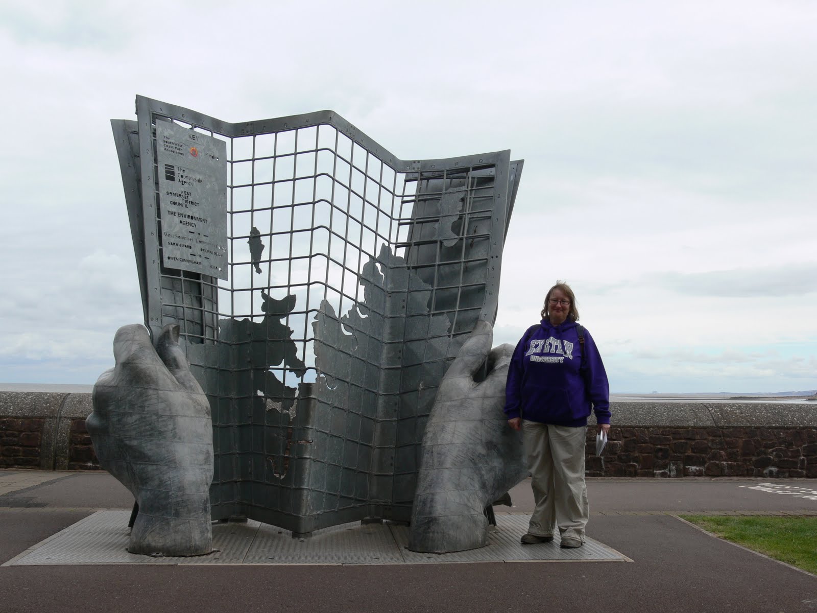
The knee-aching descent through Hurlestone Combe was followed by a pleasant flat walk through Bossington and across the back of Porlock Beach and the eerie marshland populated with dead trees, killed by the encroaching salt water.
A final walk over the large pebbles on Porlock beach led up steps to the road. Finally back to the car park and a nice pub meal.
Subscribe to:
Posts (Atom)