Stage Distance: 7 miles (Total Distance: 141 miles)
The path climbs out of Crackington Haven, past Bray's Point to Cambeak. Beyond The Strand and The Strangles comes the climb to the top of the 700ft High Cliff. From here, the rock arch called Nether Door can be seen below Cambeak. Time for installment one of the mince pies and nuts.
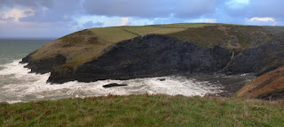
After another steep descent and ascent, we reach Buckator, with great views back along the coast. Another descent from Buckator into a hanging valley above Gull Rock, mince pies and some nuts, and then the obligatory climb again. Gull Rock looks black and menacing in the seething white water below. We pass a small huddle of ponies with their backs to the wind and soon see the Beeny Sisters below, a number of small semi-submerged rocks in amongst the white water. On past Seals Hole to Pentargon and on to the rather impressive waterfall fed from Beeny, throwing spray backwards all over us. The path then passes along Pentargon Cliff, where it runs along a steep slope down to sheer cliffs below. Not a good place to roll down and a bit unnerving in the high wind. From here, the coast to Tintagel can be seen through the salt spray with ominous clouds overhead.
Finally Penally Hill is reached, with Boscastle harbour spread out below. The lights are just coming on in Boscastle and checking the pedometer, the walk has been more like 9 miles that the expected 7. A bit longer and we would have been walking in the dark. The path descends gradually to the harbour side. The tide is coming in fast and flowing in through the harbour wall upstream. A little walk along the leat and we reach the car park.We're feeling a bit dizzy from the constant buffeting of the wind. Surprisingly, the only remnants of our food supply are the satsumas.
Logistics: Park in Boscastle and drive second car back to Crackington Haven.
GPS Track: 18 - Crackiington Haven to Boscastle (20111228).kmz
Images: 18 - Crackington Haven to Boscastle


